
La Feria topographic map
Interactive map
Click on the map to display elevation.
About this map
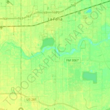
Name: La Feria topographic map, elevation, terrain.
Location: La Feria, Cameron County, Texas, 78559, United States (26.06842 -97.85780 26.17795 -97.80131)
Average elevation: 59 ft
Minimum elevation: 30 ft
Maximum elevation: 79 ft
Cameron County trails, hiking, mountain biking, running and outdoor activities
Other topographic maps
Click on a map to view its topography, its elevation and its terrain.
Windsong Village Colonia
United States > Texas > Cameron County > La Feria > Windsong Village Colonia
Average elevation: 62 ft
Boca Chica and Medford Colonia
United States > Texas > Cameron County > Reid Hope King > Boca Chica and Medford Colonia
Average elevation: 26 ft