
Meeker topographic map
Interactive map
Click on the map to display elevation.
Meeker
According to the United States Census Bureau, the town has a total area of 2.9 square miles (7.5 km2), all of it land. The town is situated on the White River at an elevation of 6,250 feet above sea level.
About this map
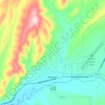
Name: Meeker topographic map, elevation, terrain.
Location: Meeker, Rio Blanco County, Colorado, United States (40.03028 -107.93516 40.07082 -107.86238)
Average elevation: 6,614 ft
Minimum elevation: 6,165 ft
Maximum elevation: 7,631 ft
Rio Blanco County trails, hiking, mountain biking, running and outdoor activities
Other topographic maps
Click on a map to view its topography, its elevation and its terrain.
Sleepy Cat Peak
United States > Colorado > Rio Blanco County
Sleepy Cat Peak, elevation 10,853 ft (3,308 m), is a summit in the Flat Tops of northwest Colorado. The mountain is east of Meeker in the White River National Forest of Rio Blanco County.
Average elevation: 10,138 ft