
Port Hadlock topographic map
Interactive map
Click on the map to display elevation.
About this map
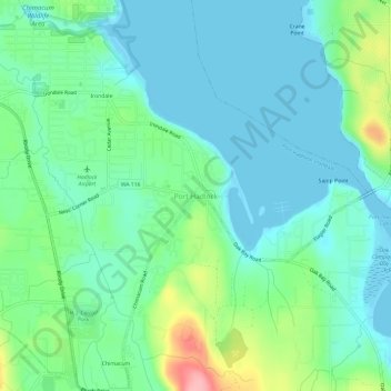
Name: Port Hadlock topographic map, elevation, terrain.
Average elevation: 102 ft
Minimum elevation: -7 ft
Maximum elevation: 407 ft
Jefferson County trails, hiking, mountain biking, running and outdoor activities
Other topographic maps
Click on a map to view its topography, its elevation and its terrain.
Hoh River
United States > Washington > Jefferson County
The Hoh River Trail, managed by the National Park Service, begins at the national park's Hoh Rain Forest Visitor Center at the end of the Upper Hoh Road. The trail follows the Hoh River east into the heart of the park. After 17.5 mi (28.2 km) it reaches Glacier Meadows near Mount Olympus's Blue Glacier. The…
Average elevation: 1,752 ft
Fort Townsend Historical State Park
United States > Washington > Jefferson County
Average elevation: 187 ft
Hoh River
United States > Washington > Jefferson County
The Hoh River Trail, managed by the National Park Service, begins at the national park's Hoh Rain Forest Visitor Center at the end of the Upper Hoh Road. The trail follows the Hoh River east into the heart of the park. After 17.5 mi (28.2 km) it reaches Glacier Meadows near Mount Olympus's Blue Glacier. The…
Average elevation: 1,742 ft