Geolocate

Damon Mound topographic map

Interactive map

Click on the map to display elevation.

About this map

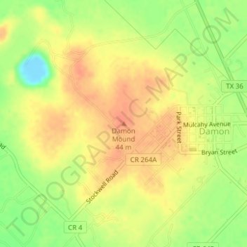
Name: Damon Mound topographic map, elevation, terrain.

Location: Damon Mound, Brazoria County, Texas, United States of America (29.29131 -95.74611 29.29141 -95.74601)

Average elevation: 92 ft

Minimum elevation: -10 ft

Maximum elevation: 148 ft

Other topographic maps

Click on a map to view its topography, its elevation and its terrain.

Huntsville

United States of America > Texas > Huntsville

Average elevation: 1,152 ft

Medina Lake

United States of America > Texas

Average elevation: 1,194 ft

Ranger

United States of America > Texas > Ranger

Average elevation: 1,496 ft

Brazos River

United States of America > Texas

Average elevation: 935 ft

Millican

United States of America > Texas > Millican

Average elevation: 302 ft

Sun Valley

United States of America > Texas > Sun Valley

Average elevation: 545 ft

Hico

United States of America > Texas > Hico

Average elevation: 1,073 ft

Tar Island

United States of America > Texas

Average elevation: 174 ft

Cool

United States of America > Texas > Cool > Cool

Average elevation: 932 ft

Bryson

United States of America > Texas > Bryson

Average elevation: 1,250 ft