
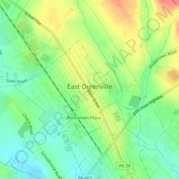
East Greenville topographic map
Interactive map
Click on the map to display elevation.
About this map
Name: East Greenville topographic map, elevation, terrain.
Average elevation: 374 ft
Minimum elevation: 285 ft
Maximum elevation: 499 ft
Other topographic maps
Click on a map to view its topography, its elevation and its terrain.
Gettysburg National Military Park
United States of America > Pennsylvania > Gettysburg
Average elevation: 545 ft
Codorus State Park
United States of America > Pennsylvania > West Manheim Township > Fuhrmans Mill
Average elevation: 709 ft
Radnor Station
United States of America > Pennsylvania > Radnor Township > Radnor Station
Average elevation: 390 ft
Gorton
United States of America > Pennsylvania > Snow Shoe Township > Gorton
Average elevation: 1,598 ft
Sizerville
United States of America > Pennsylvania > Portage Township > Sizerville
Average elevation: 1,604 ft
Harmar Heights
United States of America > Pennsylvania > Harmar Township > Harmar Heights
Average elevation: 935 ft
Swarts
United States of America > Pennsylvania > Washington Township > Swarts
Average elevation: 1,198 ft
Hawk Mountain
United States of America > Pennsylvania > East Brunswick Township
Average elevation: 1,001 ft
Highland Park
United States of America > Pennsylvania > Lower Allen > Highland Park
Average elevation: 394 ft
Bryan Hill Manor
United States of America > Pennsylvania > White Township > Bryan Hill Manor
Average elevation: 1,368 ft
Bethlehem View
United States of America > Pennsylvania > Bethlehem > Bethlehem View
Average elevation: 344 ft
Harmony Junction
United States of America > Pennsylvania > Harmony Junction
Average elevation: 1,037 ft
Pleasant View Summit
United States of America > Pennsylvania > Pleasant View Summit
Average elevation: 1,985 ft
Twin Churchs
United States of America > Pennsylvania > Sandycreek Township > Twin Churchs
Average elevation: 1,447 ft