
Clymer topographic map
Interactive map
Click on the map to display elevation.
About this map
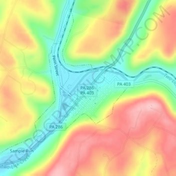
Name: Clymer topographic map, elevation, terrain.
Location: Clymer, Indiana County, Pennsylvania, United States (40.65794 -79.02810 40.68249 -79.00130)
Average elevation: 1,450 ft
Minimum elevation: 1,204 ft
Maximum elevation: 1,703 ft
Indiana County trails, hiking, mountain biking, running and outdoor activities