
Make a donation
Gear up for your next adventure:
As an Amazon Associate, this site earns from qualifying purchases at no extra cost to you.
Bradford topographic map
Click on the map to display elevation.
Make a donation
Gear up for your next adventure:
As an Amazon Associate, this site earns from qualifying purchases at no extra cost to you.
Bradford
Bradford Regional Airport is located approximately 15 miles (24 km) south of the city, at Mount Alton. The elevation of the city is 1,443 feet (440 meters) above sea level, but the airport is at an elevation of 2,142 feet (653 meters) above sea level. Because of the higher elevation, the airport often has the coldest reported air temperatures in Pennsylvania. The airport has one of the few National Weather Service stations across the entire northern tier of the state. Temperatures in the city are typically three to seven degrees warmer than at the airport due to the difference in elevation, and actual city temperatures are more representative of other communities in northern Pennsylvania and southwestern New York than are the airport's.
Make a donation
Gear up for your next adventure:
As an Amazon Associate, this site earns from qualifying purchases at no extra cost to you.
About this map
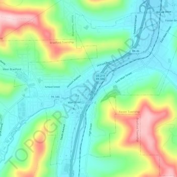
Name: Bradford topographic map, elevation, terrain.
Location: Bradford, McKean County, Pennsylvania, 16701, United States (41.94125 -78.67072 41.97693 -78.61504)
Average elevation: 1,673 ft
Minimum elevation: 1,411 ft
Maximum elevation: 2,247 ft
McKean County trails, hiking, mountain biking, running and outdoor activities
Make a donation
Gear up for your next adventure:
As an Amazon Associate, this site earns from qualifying purchases at no extra cost to you.
Other topographic maps
Click on a map to view its topography, its elevation and its terrain.
Hazelton Mills
United States > Pennsylvania > McKean County > Bradford Township
Average elevation: 1,962 ft
Hazelton Mills
United States > Pennsylvania > McKean County > Bradford Township
Average elevation: 1,962 ft