
Robesonia topographic map
Interactive map
Click on the map to display elevation.
About this map
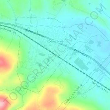
Name: Robesonia topographic map, elevation, terrain.
Location: Robesonia, Berks County, Pennsylvania, 19551, United States (40.33890 -76.14795 40.35770 -76.12724)
Average elevation: 505 ft
Minimum elevation: 361 ft
Maximum elevation: 948 ft
Berks County trails, hiking, mountain biking, running and outdoor activities
Other topographic maps
Click on a map to view its topography, its elevation and its terrain.
Lake Ontelaunee Dam
United States > Pennsylvania > Berks County > Ontelaunee Township
Average elevation: 325 ft
Spring Creek
United States > Pennsylvania > Berks County > Lower Heidelberg Township
Average elevation: 384 ft
Pricetown
United States > Pennsylvania > Berks County > Ruscombmanor Township
Average elevation: 784 ft
Maiden Creek
United States > Pennsylvania > Berks County > Maidencreek Township > Blandon
Average elevation: 367 ft
Mertztown
United States > Pennsylvania > Berks County > Longswamp Township > Longswamp
Average elevation: 502 ft
Huffs Church
United States > Pennsylvania > Berks County > Hereford Township
Average elevation: 856 ft
Eagle Point
United States > Pennsylvania > Berks County > Maxatawny Township
Average elevation: 548 ft
Windsor Castle
United States > Pennsylvania > Berks County > Windsor Township
Average elevation: 512 ft
Landis Store
United States > Pennsylvania > Berks County > District Township
Average elevation: 876 ft
Pennside
United States > Pennsylvania > Berks County > Lower Alsace Township
Average elevation: 600 ft
Stony Creek Mills
United States > Pennsylvania > Berks County > Lower Alsace Township > Pennside
Average elevation: 630 ft
Montrose Manor Playground
United States > Pennsylvania > Berks County > Cumru Township > Montrose
Average elevation: 427 ft
Maple Grove
United States > Pennsylvania > Berks County > Longswamp Township
Average elevation: 646 ft
New Berlinville
United States > Pennsylvania > Berks County > Colebrookdale Township
Average elevation: 430 ft
New Jerusalem
United States > Pennsylvania > Berks County > Rockland Township
Average elevation: 827 ft
Rehrersburg
United States > Pennsylvania > Berks County > Tulpehocken Township
Average elevation: 541 ft
Fredericksville
United States > Pennsylvania > Berks County > District Township
Average elevation: 978 ft
Pleasantville Park
United States > Pennsylvania > Berks County > Oley Township > Manatawny
Average elevation: 397 ft
Shartlesville
United States > Pennsylvania > Berks County > Upper Bern Township
Average elevation: 600 ft
State Hill
United States > Pennsylvania > Berks County > Lower Heidelberg Township
Average elevation: 348 ft
Trexler
United States > Pennsylvania > Berks County > Albany Township > Kempton
Average elevation: 538 ft
Green Hills Lake Dam
United States > Pennsylvania > Berks County > Robeson Township
Average elevation: 413 ft
Breezy Corner
United States > Pennsylvania > Berks County > Ruscombmanor Township
Average elevation: 827 ft
Henningsville
United States > Pennsylvania > Berks County > Longswamp Township
Average elevation: 965 ft
Hyde Park
United States > Pennsylvania > Berks County > Muhlenberg Township > Muhlenberg Park
Average elevation: 351 ft
Wintersville
United States > Pennsylvania > Berks County > Tulpehocken Township
Average elevation: 564 ft
Seisholtzville
United States > Pennsylvania > Berks County > Hereford Township
Average elevation: 853 ft
Cacoosing
United States > Pennsylvania > Berks County > Lower Heidelberg Township
Average elevation: 335 ft
Brownsville
United States > Pennsylvania > Berks County > Lower Heidelberg Township
Average elevation: 413 ft
Hinterleiter
United States > Pennsylvania > Berks County > Maxatawny Township
Average elevation: 463 ft
Saint Lawrence Playground
United States > Pennsylvania > Berks County > St. Lawrence
Average elevation: 436 ft
Moselem Springs
United States > Pennsylvania > Berks County > Richmond Township
Average elevation: 407 ft
Morysville
United States > Pennsylvania > Berks County > Colebrookdale Township
Average elevation: 440 ft
Alleghenyville
United States > Pennsylvania > Berks County > Brecknock Township
Average elevation: 689 ft
Klinesville
United States > Pennsylvania > Berks County > Greenwich Township
Average elevation: 594 ft
Boyers Junction
United States > Pennsylvania > Berks County > Rockland Township
Average elevation: 794 ft
Jacksonwald
United States > Pennsylvania > Berks County > Exeter Township > Village of Jacksonwald
Average elevation: 420 ft