Geolocate

Carrabelle topographic map

Interactive map

Click on the map to display elevation.

About this map

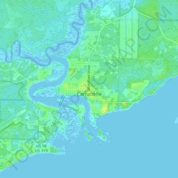
Name: Carrabelle topographic map, elevation, terrain.

Location: Carrabelle, Franklin County, Florida, United States (29.82917 -84.71969 29.88103 -84.64283)

Average elevation: 10 ft

Minimum elevation: -13 ft

Maximum elevation: 49 ft

Other topographic maps

Click on a map to view its topography, its elevation and its terrain.

Saint George Island

United States > Florida > Franklin County

Saint George Island, Franklin County, Florida, United States

Average elevation: 3 ft

Saint George Island

United States > Florida > Franklin County

Saint George Island, Franklin County, Florida, 32328, United States

Average elevation: 7 ft

Apalachicola

United States > Florida > Franklin County

Apalachicola, Franklin County, Florida, 32320, United States

Average elevation: 7 ft

Eastpoint

United States > Florida > Franklin County

Eastpoint, Franklin County, Florida, United States

Average elevation: 7 ft