
Fairborn topographic map
Interactive map
Click on the map to display elevation.
About this map
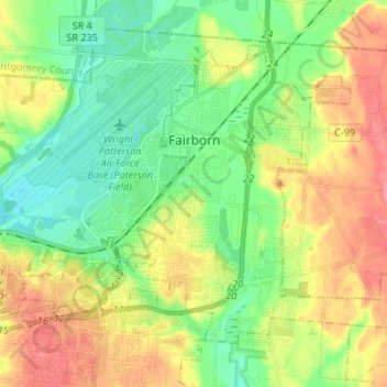
Name: Fairborn topographic map, elevation, terrain.
Location: Fairborn, Greene County, Ohio, United States (39.76724 -84.07915 39.84597 -83.94604)
Average elevation: 892 ft
Minimum elevation: 781 ft
Maximum elevation: 1,056 ft
Greene County trails, hiking, mountain biking, running and outdoor activities
Other topographic maps
Click on a map to view its topography, its elevation and its terrain.
New Germany
United States > Ohio > Greene County > Beavercreek > New Germany
Average elevation: 922 ft