Geolocate

Ravenna topographic map

Interactive map

Click on the map to display elevation.

About this map

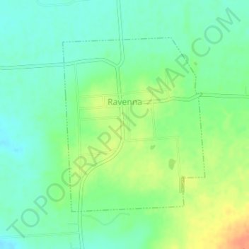
Name: Ravenna topographic map, elevation, terrain.

Location: Ravenna, Fannin County, Texas, United States (33.66098 -96.24975 33.67985 -96.23122)

Average elevation: 587 ft

Minimum elevation: 538 ft

Maximum elevation: 669 ft

Other topographic maps

Click on a map to view its topography, its elevation and its terrain.

Ivanhoe

United States > Texas > Fannin County

Ivanhoe, Fannin County, Texas, 75447, United States

Average elevation: 604 ft

Burnett

United States > Texas > Fannin County

Burnett, Fannin County, Texas, 75492, United States

Average elevation: 643 ft

Ely

United States > Texas > Fannin County

Ely, Fannin County, Texas, United States

Average elevation: 719 ft

Flag Springs

United States > Texas > Fannin County

Flag Springs, Fannin County, Texas, 75492, United States

Average elevation: 646 ft

Savoy

United States > Texas > Fannin County

Savoy, Fannin County, Texas, United States

Average elevation: 669 ft

Bonham

United States > Texas > Fannin County

Bonham, Fannin County, Texas, 75418, United States

Average elevation: 604 ft

Bonham

United States > Texas > Fannin County > Bonham > Bonham

Bonham, Fannin County, Texas, 75418, United States

Average elevation: 604 ft

Honey Grove

United States > Texas > Fannin County

Honey Grove, Fannin County, Texas, 75446, United States

Average elevation: 640 ft

Bailey

United States > Texas > Fannin County > Bailey

Bailey, Fannin County, Texas, United States

Average elevation: 715 ft

Allens Chapel

United States > Texas > Fannin County > Allens Chapel

Allens Chapel, Fannin County, Texas, United States

Average elevation: 577 ft

Telephone

United States > Texas > Fannin County

Telephone, Fannin County, Texas, 75488, United States

Average elevation: 564 ft

Gober

United States > Texas > Fannin County > Gober

Gober, Fannin County, Texas, 75443, United States

Average elevation: 653 ft