
Sugar Creek topographic map
Interactive map
Click on the map to display elevation.
About this map
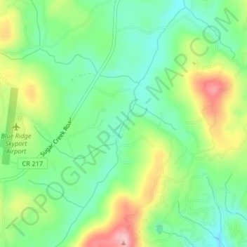
Name: Sugar Creek topographic map, elevation, terrain.
Average elevation: 1,880 ft
Minimum elevation: 1,690 ft
Maximum elevation: 2,201 ft
Other topographic maps
Click on a map to view its topography, its elevation and its terrain.
Statesboro
United States of America > Georgia > Statesboro
According to the United States Census Bureau, the city has a total area of 13.9 square miles (35.9 km2), of which 13.5 square miles (35.0 km2) is land and 0.35 square miles (0.9 km2), or 2.60%, is water. The city is in the coastal plain region, or Low Country, of Georgia, so it is mainly flat with a few small…
Average elevation: 217 ft
Johns Creek
United States of America > Georgia > Johns Creek
Johns Creek is located in northeastern Fulton County and is centered at 34°1′44″N 84°11′55″W / 34.02889°N 84.19861°W / 34.02889; -84.19861 (34.0289259, -84.1985790). The elevation ranges from 880 feet (270 m) above sea level along the Chattahoochee River to 1,180 feet (360 m) in the Ocee…
Average elevation: 1,030 ft
Sunnydale Acres
United States of America > Georgia > Macon > Sunnydale Acres
Average elevation: 371 ft