
Free Union topographic map
Interactive map
Click on the map to display elevation.
About this map
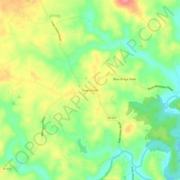
Name: Free Union topographic map, elevation, terrain.
Location: Free Union, Albemarle County, Virginia, 22940, United States (38.13486 -78.58446 38.17486 -78.54446)
Average elevation: 528 ft
Minimum elevation: 394 ft
Maximum elevation: 696 ft
Albemarle County trails, hiking, mountain biking, running and outdoor activities
Other topographic maps
Click on a map to view its topography, its elevation and its terrain.
Beaver Creek Park
United States > Virginia > Albemarle County > Charlottesville > Wickham Pond
Average elevation: 607 ft
Darden Towe Park
United States > Virginia > Albemarle County > Charlottesville > Franklin
Average elevation: 423 ft