
Austera Peak topographic map
Interactive map
Click on the map to display elevation.
About this map
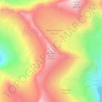
Name: Austera Peak topographic map, elevation, terrain.
Average elevation: 7,096 ft
Minimum elevation: 5,259 ft
Maximum elevation: 8,474 ft
Other topographic maps
Click on a map to view its topography, its elevation and its terrain.
Olympic Sculpture Park
United States of America > Washington > Seattle > Lower Queen Anne
Average elevation: 62 ft
Lake Ballinger
United States of America > Washington > Mountlake Terrace
Lake Ballinger is a natural lake formed by the melting of the Puget Sound lobe of the Cordilleran Ice Sheet. It is fed primarily by Hall Creek, but is also fed by groundwater flowing from nearby Echo Lake as well as by surface runoff. It is just west of Interstate 5 in Mountlake Terrace and immediately north…
Average elevation: 381 ft
Green Lake
United States of America > Washington > Okanogan County > Brown Lake
Average elevation: 2,224 ft