
Pennington Gap topographic map
Interactive map
Click on the map to display elevation.
About this map
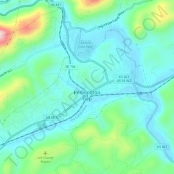
Name: Pennington Gap topographic map, elevation, terrain.
Location: Pennington Gap, Lee County, Virginia, 24277, United States (36.74765 -83.05595 36.77266 -83.00978)
Average elevation: 1,578 ft
Minimum elevation: 1,329 ft
Maximum elevation: 2,428 ft
Lee County trails, hiking, mountain biking, running and outdoor activities
Other topographic maps
Click on a map to view its topography, its elevation and its terrain.
Cumberland Gap
United States > Virginia > Lee County
The Cumberland Gap is a pass in the eastern United States through the long ridge of the Cumberland Mountains, within the Appalachian Mountains and near the tripoint of Kentucky, Virginia, and Tennessee. At an elevation of 1,631 feet (497 m) above sea level, it is famous in American colonial history for its…
Average elevation: 1,680 ft