
New Haven topographic map
Interactive map
Click on the map to display elevation.
About this map
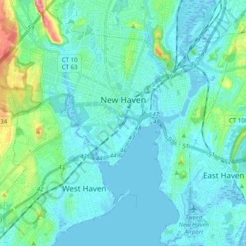
Name: New Haven topographic map, elevation, terrain.
Location: New Haven, New Haven County, Connecticut, United States (41.24643 -72.99805 41.35039 -72.86042)
Average elevation: 72 ft
Minimum elevation: -10 ft
Maximum elevation: 453 ft
New Haven County trails, hiking, mountain biking, running and outdoor activities
Other topographic maps
Click on a map to view its topography, its elevation and its terrain.
Morris Cove
United States > Connecticut > New Haven County > New Haven > Morris Cove
Average elevation: 10 ft
Barnesville
United States > Connecticut > New Haven County > New Haven > Barnesville
Average elevation: 36 ft