
Prince of Wales Island topographic map
Interactive map
Click on the map to display elevation.
About this map
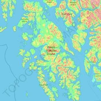
Name: Prince of Wales Island topographic map, elevation, terrain.
Average elevation: 397 ft
Minimum elevation: -20 ft
Maximum elevation: 4,833 ft
Other topographic maps
Click on a map to view its topography, its elevation and its terrain.
Chugach Mountains
United States of America > Alaska
The Chugach Mountains of southern Alaska are the northernmost of the several mountain ranges that make up the Pacific Coast Ranges of the western edge of North America. The range is about 250 miles (402 km) long and 60 miles (97 km) wide, and extends from the Knik and Turnagain Arms of the Cook Inlet on the…
Average elevation: 8,301 ft
Hubbard Glacier
United States of America > Alaska
The longest source for Hubbard Glacier originates 122 kilometres (76 mi) from its snout and is located at about 61°00′N 140°09′W / 61.000°N 140.150°W / 61.000; -140.150, approximately 8 kilometres (5 mi) west of Mount Walsh with an elevation around 11,000 feet (3,400 m). A shorter tributary…
Average elevation: 3,110 ft