
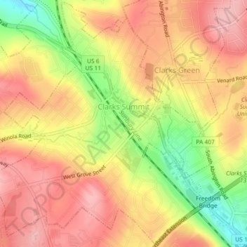
Clarks Summit topographic map
Interactive map
Click on the map to display elevation.
About this map
Name: Clarks Summit topographic map, elevation, terrain.
Average elevation: 1,348 ft
Minimum elevation: 1,063 ft
Maximum elevation: 1,522 ft
Lackawanna County trails, hiking, mountain biking, running and outdoor activities
Other topographic maps
Click on a map to view its topography, its elevation and its terrain.
Madisonville
United States > Pennsylvania > Lackawanna County > Madison Township
Average elevation: 1,680 ft
Montage Mountain
United States > Pennsylvania > Lackawanna County > Scranton
Average elevation: 1,585 ft
Spring Brook
United States > Pennsylvania > Lackawanna County > Spring Brook Township
Average elevation: 1,519 ft
Mount Cobb
United States > Pennsylvania > Lackawanna County > Jefferson Township
Average elevation: 1,736 ft
Birchwood Estates
United States > Pennsylvania > Lackawanna County > Roaring Brook Township
Average elevation: 1,680 ft
Elmhurst
United States > Pennsylvania > Lackawanna County > Elmhurst Township
Average elevation: 1,568 ft
Eagle Lake
United States > Pennsylvania > Lackawanna County > Covington Township
Average elevation: 1,896 ft