
Lamesa topographic map
Interactive map
Click on the map to display elevation.
About this map
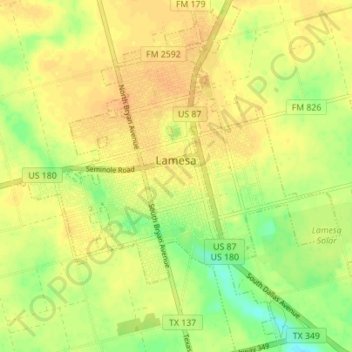
Name: Lamesa topographic map, elevation, terrain.
Location: Lamesa, Dawson County, Texas, 79331, United States (32.70401 -101.98638 32.76229 -101.92270)
Average elevation: 2,976 ft
Minimum elevation: 2,910 ft
Maximum elevation: 3,015 ft
Dawson County trails, hiking, mountain biking, running and outdoor activities
Other topographic maps
Click on a map to view its topography, its elevation and its terrain.