
Glen Burnie topographic map
Interactive map
Click on the map to display elevation.
About this map
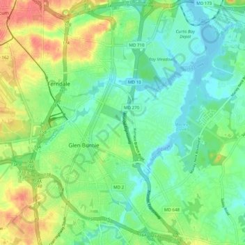
Name: Glen Burnie topographic map, elevation, terrain.
Location: Glen Burnie, Anne Arundel County, Maryland, United States (39.11097 -76.64549 39.20794 -76.56319)
Average elevation: 79 ft
Minimum elevation: -7 ft
Maximum elevation: 217 ft
Other topographic maps
Click on a map to view its topography, its elevation and its terrain.
Willowdale
United States > Maryland > Anne Arundel County > Glen Burnie > Willowdale
Willowdale, Glen Burnie, Anne Arundel County, Maryland, 21061, United States
Average elevation: 75 ft