
Make a donation
Gear up for your next adventure:
As an Amazon Associate, this site earns from qualifying purchases at no extra cost to you.
Glen Burnie topographic map
Click on the map to display elevation.
Make a donation
Gear up for your next adventure:
As an Amazon Associate, this site earns from qualifying purchases at no extra cost to you.
About this map
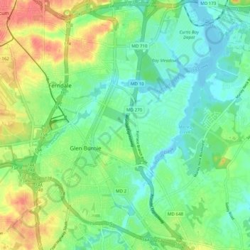
Name: Glen Burnie topographic map, elevation, terrain.
Location: Glen Burnie, Anne Arundel County, Maryland, United States (39.11097 -76.64549 39.20794 -76.56319)
Average elevation: 79 ft
Minimum elevation: -7 ft
Maximum elevation: 217 ft
Anne Arundel County trails, hiking, mountain biking, running and outdoor activities
Make a donation
Gear up for your next adventure:
As an Amazon Associate, this site earns from qualifying purchases at no extra cost to you.
Other topographic maps
Click on a map to view its topography, its elevation and its terrain.
Edinboro Estates
United States > Maryland > Anne Arundel County > Glen Burnie
Average elevation: 79 ft
Make a donation
Gear up for your next adventure:
As an Amazon Associate, this site earns from qualifying purchases at no extra cost to you.
Glen Burnie Park
United States > Maryland > Anne Arundel County > Glen Burnie
Average elevation: 92 ft
Make a donation
Gear up for your next adventure:
As an Amazon Associate, this site earns from qualifying purchases at no extra cost to you.