
Kearny topographic map
Interactive map
Click on the map to display elevation.
Kearny
The town is varied in topography and roughly divided into three parts: the Kearny Uplands, the Kearny Meadows and South Kearny, which is located where the Hackensack and Passaic rivers meet. Main thoroughfares include the eponymous Kearny Avenue (the local segment of Ridge Road / Frank E. Rodgers Boulevard), Bergen Avenue, Midland Avenue, Schuyler Avenue and Passaic Avenue.
About this map
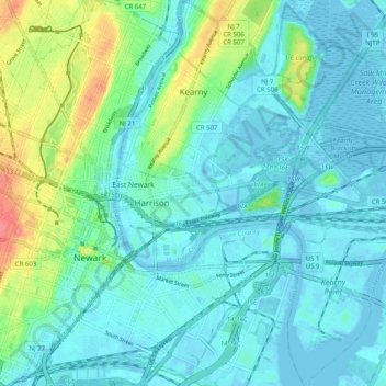
Name: Kearny topographic map, elevation, terrain.
Location: Kearny, Hudson County, New Jersey, 07032, United States (40.71060 -74.16475 40.78649 -74.07475)
Average elevation: 46 ft
Minimum elevation: -20 ft
Maximum elevation: 213 ft
Hudson County trails, hiking, mountain biking, running and outdoor activities
Other topographic maps
Click on a map to view its topography, its elevation and its terrain.
Marion
United States > New Jersey > Hudson County > Jersey City > Journal Square
Average elevation: 39 ft
Hudson River Waterfront
United States > New Jersey > Hudson County > Jersey City
Average elevation: 7 ft
North End Business District
United States > New Jersey > Hudson County > Secaucus
Average elevation: 13 ft