
Port Saint Joe topographic map
Interactive map
Click on the map to display elevation.
About this map
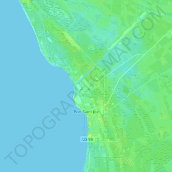
Name: Port Saint Joe topographic map, elevation, terrain.
Location: Port Saint Joe, Gulf County, Florida, United States (29.76616 -85.35852 29.89570 -85.26330)
Average elevation: 10 ft
Minimum elevation: -3 ft
Maximum elevation: 46 ft
Other topographic maps
Click on a map to view its topography, its elevation and its terrain.
White City
United States > Florida > Gulf County
White City, Gulf County, Florida, United States
Average elevation: 20 ft
Lake Grove
United States > Florida > Gulf County > Wewahitchka
Lake Grove, Wewahitchka, Gulf County, Florida, United States
Average elevation: 26 ft
Wewahitchka
United States > Florida > Gulf County
Wewahitchka, Gulf County, Florida, United States
Average elevation: 30 ft
Indian Pass
United States > Florida > Gulf County > Indian Pass
Indian Pass, Gulf County, Florida, United States
Average elevation: 7 ft
Big Bertha Swamp
United States > Florida > Gulf County
Big Bertha Swamp, Gulf County, Florida, United States
Average elevation: 46 ft