
Kodiak Island topographic map
Interactive map
Click on the map to display elevation.
About this map
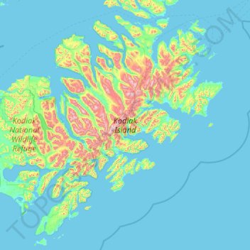
Name: Kodiak Island topographic map, elevation, terrain.
Location: Kodiak Island, Alaska, USA (56.74293 -154.79900 57.99976 -152.15431)
Average elevation: 394 ft
Minimum elevation: -7 ft
Maximum elevation: 4,226 ft
Other topographic maps
Click on a map to view its topography, its elevation and its terrain.