
Wilsonville topographic map
Interactive map
Click on the map to display elevation.
Wilsonville
Wilsonville is located on the southern edge of the Portland metropolitan area sitting at an elevation of 154 feet (47 m) above sea level. Primarily in the southwestern part of Clackamas County, the northern section is in Washington County. It is located on the north side of the Willamette River around where Alphonse Boone established the Boones Ferry. Neighboring cities are Tualatin on the north, Sherwood to the northwest, and Canby and Aurora to the southeast. Newberg in Yamhill County is approximately 14 miles west along Wilsonville Road. The Willamette separates the majority of the city from Charbonneau, a planned community and neighborhood within the city limits, on the south.
About this map
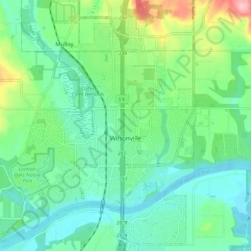
Name: Wilsonville topographic map, elevation, terrain.
Average elevation: 197 ft
Minimum elevation: 59 ft
Maximum elevation: 594 ft
Clackamas County trails, hiking, mountain biking, running and outdoor activities
Other topographic maps
Click on a map to view its topography, its elevation and its terrain.
Sherwood Forest Tot Lot
United States > Oregon > Clackamas County > Gladstone
Average elevation: 210 ft
Wilhoit Springs County Park
United States > Oregon > Clackamas County > Wilhoit
Average elevation: 1,033 ft