
Bosque de Chapultepec topographic map
Interactive map
Click on the map to display elevation.
About this map
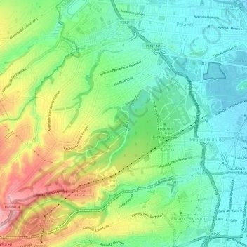
Name: Bosque de Chapultepec topographic map, elevation, terrain.
Average elevation: 7,621 ft
Minimum elevation: 7,356 ft
Maximum elevation: 8,123 ft
Other topographic maps
Click on a map to view its topography, its elevation and its terrain.
Xochimilco
Much of the borough's land is former lakebed. Its main elevations include Xochitepec and Tlacualleli mountains along with two volcanoes named Teutli and Tzompol. It contains two natural rivers called Santiago and Tepapantla along with the various canals, which is what is left of the lake. The elevated areas of…
Average elevation: 7,352 ft