
Asterstein topographic map
Click on the map to display elevation.
Asterstein
Koblenz-Asterstein ist der jüngste Stadtteil von Koblenz. Er liegt auf der rechten Rheinseite zwischen Pfaffendorf und Arzheim. Auf dem Asterstein wohnen 2.929 Menschen, davon sind 49,2 % männlich und 50,8 % weiblich (Stand: 31. Dezember 2019). Ursprünglich gehörte das Gebiet auf einem Bergrücken zur Pfaffendorfer Höhe und wurde 1982 zu einem eigenen Stadtteil gebildet. Neben einem reinen Wohngebiet befindet sich hier die Feuerwehr- und Katastrophenschutzakademie Rheinland-Pfalz.
About this map
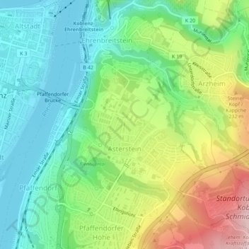
Name: Asterstein topographic map, elevation, terrain.
Location: Asterstein, Koblenz, Rheinland-Pfalz, Deutschland (50.34295 7.60672 50.35733 7.62985)
Average elevation: 489 ft
Minimum elevation: 203 ft
Maximum elevation: 1,027 ft
Other topographic maps
Click on a map to view its topography, its elevation and its terrain.
Koblenz
Deutschland > Rheinland-Pfalz > Koblenz
Koblenz liegt laut Angabe des Bundesamtes für Kartographie und Geodäsie auf 73 m ü. NHN. Das Deutsche Eck liegt bei 64,7 m Höhe. Die höchste vollständig im Stadtgebiet gelegene Erhebung ist mit 382 m der Kühkopf im Stadtwald. Die höchste Stelle des Stadtgebietes mit 385 m befindet sich auf der Grenze…
Average elevation: 787 ft