
Garanhuns topographic map
Interactive map
Click on the map to display elevation.
Garanhuns
Garanhuns is a city in the Brazilian state of Pernambuco. Located in the Borborema Plateau, the town is known as the "Suíça Pernambucana" (Pernambucan Switzerland) due to its elevation and relatively cool climate. It is also known as "Cidade das Flores" ("City of Flowers") or "Cidade da Garoa" ("City of Drizzle").
About this map
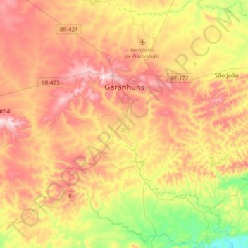
Name: Garanhuns topographic map, elevation, terrain.
Average elevation: 2,421 ft
Minimum elevation: 1,460 ft
Maximum elevation: 3,340 ft
Other topographic maps
Click on a map to view its topography, its elevation and its terrain.
Santa Fé
Brazil > Pernambuco > Região Administrativa Integrada de Desenvolvimento do Polo Petrolina e Juazeiro > Petrolina
Average elevation: 1,342 ft
Ana de Alburquerque
Brazil > Pernambuco > Região Metropolitana do Recife > Igarassu
Average elevation: 56 ft
Região Metropolitana do Recife
Brazil > Pernambuco > Região Metropolitana do Recife > Cabo de Santo Agostinho
Average elevation: 390 ft
Saint Peter and Saint Paul Archipelago
The Saint Peter and Saint Paul Rocks are situated in the Atlantic Ocean, 100 km (62 mi) north of the Equator and are the only group of Brazilian oceanic islets in the Northern Hemisphere. The nearest point in the Brazilian coast, is Cabo do Calcanhar, Rio Grande do Norte, approximately 1,010 kilometres (630…
Average elevation: 0 ft