
Rmeil topographic map
Interactive map
Click on the map to display elevation.
About this map
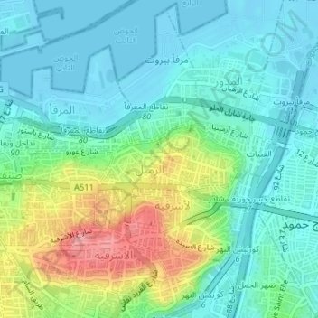
Name: Rmeil topographic map, elevation, terrain.
Location: Rmeil, Beirut Governorate, 2078, Lebanon (33.89121 35.51099 33.89742 35.53680)
Average elevation: 105 ft
Minimum elevation: -13 ft
Maximum elevation: 377 ft
Other topographic maps
Click on a map to view its topography, its elevation and its terrain.
Beirut
The average annual rainfall is 825 millimetres (32.5 in), with the large majority of it falling from October to April. Much of the autumn and spring rain falls in heavy downpours on a limited number of days, but in winter it is spread more evenly over many days. Summer receives very little rainfall, if any.…
Average elevation: 476 ft