
St. Olaf topographic map
Interactive map
Click on the map to display elevation.
About this map
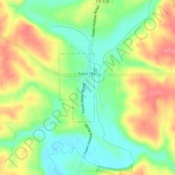
Name: St. Olaf topographic map, elevation, terrain.
Location: St. Olaf, Clayton County, Iowa, United States (42.92113 -91.39208 42.93173 -91.38466)
Average elevation: 925 ft
Minimum elevation: 814 ft
Maximum elevation: 1,056 ft
Clayton County trails, hiking, mountain biking, running and outdoor activities
Other topographic maps
Click on a map to view its topography, its elevation and its terrain.
Driftless Area National Wildlife Refuge - Fern Ridge Unit
United States > Iowa > Clayton County
Average elevation: 883 ft