
Caimito topographic map
Interactive map
Click on the map to display elevation.
About this map
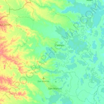
Name: Caimito topographic map, elevation, terrain.
Location: Caimito, San Jorge, Sucre, Colombia (8.61568 -75.25835 8.92420 -74.99442)
Average elevation: 95 ft
Minimum elevation: 30 ft
Maximum elevation: 292 ft
Other topographic maps
Click on a map to view its topography, its elevation and its terrain.
Puerto Asís
Colombia > Sucre > Los Palmitos
Puerto Asís, Los Palmitos, Montes de María, Sucre, Colombia
Average elevation: 600 ft
San Onofre
San Onofre, Morrosquillo, Sucre, RAP Caribe, 707017, Colombia
Average elevation: 131 ft
El Tamarindo
Colombia > Sucre > Los Palmitos > El Tamarindo
El Tamarindo, Los Palmitos, Montes de María, Sucre, Colombia
Average elevation: 636 ft