Millersburg topographic map
Interactive map
Click on the map to display elevation.
About this map
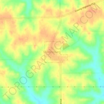
Name: Millersburg topographic map, elevation, terrain.
Location: Millersburg, Iowa County, Iowa, 52308, United States (41.57058 -92.16252 41.57612 -92.15449)
Average elevation: 840 ft
Minimum elevation: 764 ft
Maximum elevation: 892 ft
Other topographic maps
Click on a map to view its topography, its elevation and its terrain.
Williamsburg
United States > Iowa > Iowa County
Williamsburg, Iowa County, Iowa, 52361, United States
Average elevation: 814 ft
Victor
United States > Iowa > Iowa County
Victor, Iowa County, Iowa, United States
Average elevation: 833 ft
Marengo
United States > Iowa > Iowa County > Marengo
Marengo, Iowa County, Iowa, United States
Average elevation: 745 ft
North English
United States > Iowa > Iowa County
North English, Iowa County, Iowa, United States
Average elevation: 807 ft