
Sangre Grande topographic map
Interactive map
Click on the map to display elevation.
About this map
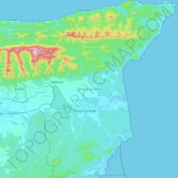
Name: Sangre Grande topographic map, elevation, terrain.
Location: Sangre Grande, Trinidad and Tobago (10.43062 -61.24477 10.84386 -60.90706)
Average elevation: 292 ft
Minimum elevation: 0 ft
Maximum elevation: 3,018 ft
Other topographic maps
Click on a map to view its topography, its elevation and its terrain.
Carapichaima
Trinidad and Tobago > Couva-Tabaquite-Talparo
Carapichaima, Couva-Tabaquite-Talparo, Trinidad and Tobago
Average elevation: 33 ft
Rambert Village
Trinidad and Tobago > Penal-Debe
Rambert Village, Penal-Debe, 600301, Trinidad and Tobago
Average elevation: 43 ft
Port of Spain
Trinidad and Tobago > Port of Spain > Port of Spain
Port of Spain, 170605, Trinidad and Tobago
Average elevation: 194 ft
Freeport
Trinidad and Tobago > Couva-Tabaquite-Talparo
Freeport, Couva-Tabaquite-Talparo, 550610, Trinidad and Tobago
Average elevation: 79 ft
Crown Point
Crown Point, Tobago, Trinidad and Tobago
Average elevation: 7 ft
Trinidad
Trinidad and Tobago > Couva-Tabaquite-Talparo
Trinidad, Couva-Tabaquite-Talparo, Trinidad and Tobago
Average elevation: 98 ft
Couva
Trinidad and Tobago > Couva-Tabaquite-Talparo > Couva
Couva, Couva-Tabaquite-Talparo, 1868, Trinidad and Tobago
Average elevation: 52 ft
Aranguez
Trinidad and Tobago > San Juan-Laventille > Aranguez
Aranguez, San Juan-Laventille, 868 370-8825, Trinidad and Tobago
Average elevation: 180 ft
Couva
Trinidad and Tobago > Couva-Tabaquite-Talparo
Couva, Couva-Tabaquite-Talparo, Trinidad and Tobago
Average elevation: 56 ft
Sea Lots
Trinidad and Tobago > Port of Spain > Sea Lots
Sea Lots, Port of Spain, 150123, Trinidad and Tobago
Average elevation: 72 ft
Valsayn
Trinidad and Tobago > Tunapuna-Piarco > Valsayn
Valsayn, Tunapuna-Piarco, 12333, Trinidad and Tobago
Average elevation: 161 ft
Trincity
Trinidad and Tobago > Port of Spain > Trincity
Trincity, Port of Spain, 350509, Trinidad and Tobago
Average elevation: 230 ft
Saint Joseph
Trinidad and Tobago > Tunapuna-Piarco > Saint Joseph
Saint Joseph, Tunapuna-Piarco, 310407, Trinidad and Tobago
Average elevation: 423 ft
Phillipines
Trinidad and Tobago > Penal-Debe
Phillipines, Penal-Debe, 600301, Trinidad and Tobago
Average elevation: 72 ft
Cocorite
Trinidad and Tobago > Diego Martin > Cocorite
Cocorite, Diego Martin, 190130, Trinidad and Tobago
Average elevation: 236 ft
Marabella
Trinidad and Tobago > San Fernando > Marabella
Marabella, San Fernando, VISTABELLA, Trinidad and Tobago
Average elevation: 56 ft
Barataria
Trinidad and Tobago > San Juan-Laventille > Champ Fleurs
Barataria, Champ Fleurs, San Juan-Laventille, Trinidad and Tobago
Average elevation: 151 ft
Sangre Grande
Trinidad and Tobago > Sangre Grande > Sangre Grande
Sangre Grande, 450626, Trinidad and Tobago
Average elevation: 69 ft
Piarco
Trinidad and Tobago > Tunapuna-Piarco
Piarco, Tunapuna-Piarco, 350509, Trinidad and Tobago
Average elevation: 72 ft