Geolocate

Rambert Village topographic map

Click on the map to display elevation.

About this map

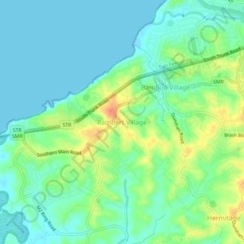
Name: Rambert Village topographic map, elevation, terrain.

Location: Rambert Village, Penal-Debe, 600301, Trinidad and Tobago (10.22827 -61.50131 10.26827 -61.46131)

Average elevation: 43 ft

Minimum elevation: -20 ft

Maximum elevation: 131 ft

Gear up for your next adventure:

GPS Sports Watch - GPS watch for running, hiking and training
🛠️Outdoor Gear Repair Kit - Essential tools to fix gear on the trail
🧣Merino Neck Gaiters - Multi-functional headwear for wind and sun protection
🚪Portable Camp Chair - Foldable chair for comfort at camp
📖Nature Tracking Books - Learn to track wildlife and terrain

As an Amazon Associate, this site earns from qualifying purchases at no extra cost to you.