
Falmouth topographic map
Interactive map
Click on the map to display elevation.
About this map
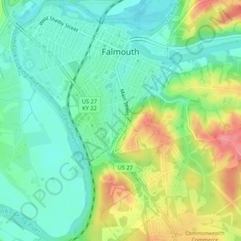
Name: Falmouth topographic map, elevation, terrain.
Location: Falmouth, Pendleton County, Kentucky, 41040, United States (38.65422 -84.34672 38.68285 -84.32125)
Average elevation: 614 ft
Minimum elevation: 509 ft
Maximum elevation: 807 ft
Pendleton County trails, hiking, mountain biking, running and outdoor activities
Other topographic maps
Click on a map to view its topography, its elevation and its terrain.