
Ngäbe-Buglé topographic map
Interactive map
Click on the map to display elevation.
Ngäbe-Buglé
As subsistence agriculture becomes less and less reliable, the Guaymí people have started to participate in the cash economy, which provides some relatively accessible alternatives for generating capital and obtaining necessary amenities and resources. Labor is one abundant resource the Guaymí possess, although due to poor education and low human capital including health and nutrition, the labor force is rather unskilled. As a result, many men serve as migrant agricultural workers or leave the comarca to seek other types of informal jobs. 2008. Many men work during the coffee harvest in the Chiriqui Highlands including Boquete and Santa Clara. This region of Panama is known for high quality shade-grown, and in some cases, organic coffee. The Guaymí also harvest seasonal vegetables grown at higher altitudes. Women also participate in the informal economy by making chacaras, naguas and jewelry to sell, and some men sew pants or weave hats to do the same. Social capital is again salient to participation in the informal economy as relationships provide people with new opportunities to make money; social capital can even be a mechanism used to attract help from both governmental and non-governmental organizations.
About this map
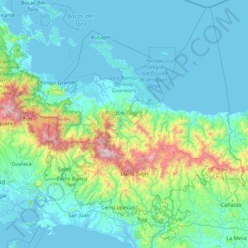
Name: Ngäbe-Buglé topographic map, elevation, terrain.
Location: Ngäbe-Buglé, Panama (8.13551 -82.42349 9.33377 -81.13779)
Average elevation: 945 ft
Minimum elevation: -7 ft
Maximum elevation: 8,130 ft
Other topographic maps
Click on a map to view its topography, its elevation and its terrain.
Embalse Río Caldera
Panama > Chiriquí > Distrito de Boquete > Alto Boquete
Average elevation: 3,537 ft
Panama Pacifico
Panama > Panamá Oeste > Distrito Arraiján > Veracruz > Panama Pacifico
Average elevation: 79 ft
Pigeon Key (cayo Paloma)
Panama > Comarca Ngäbe Buglé > Distrito Kusapín > Pigeon Key (cayo Paloma)
Average elevation: 56 ft
Fort Sherman
Panama > Colón > Distrito Colón > Cristóbal
Between 1966 and 1979, 1,160 sounding rockets with maximum flight altitudes of 99 kilometres were launched from Fort Sherman. Fort Sherman was used in the filming of the 2008 James Bond film Quantum of Solace.
Average elevation: 23 ft