
Martorell topographic map
Interactive map
Click on the map to display elevation.
About this map
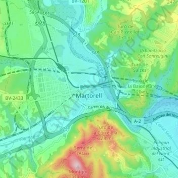
Name: Martorell topographic map, elevation, terrain.
Location: Martorell, Baix Llobregat, Barcelona, Catalonia, 08760, Spain (41.45413 1.88969 41.50341 1.95370)
Average elevation: 351 ft
Minimum elevation: 115 ft
Maximum elevation: 1,033 ft
Other topographic maps
Click on a map to view its topography, its elevation and its terrain.
Plaça de Mahatma Gandhi
Spain > Catalonia > Baix Llobregat > Esplugues de Llobregat
Average elevation: 243 ft
Poble Nou
Spain > Catalonia > Baix Llobregat > Sant Vicenç dels Horts > Poble Nou
Average elevation: 203 ft