Camden topographic map
Interactive map
Click on the map to display elevation.
About this map
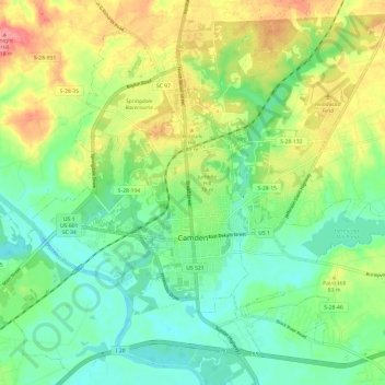
Name: Camden topographic map, elevation, terrain.
Location: Camden, Kershaw County, South Carolina, United States (34.21628 -80.65768 34.30000 -80.53743)
Average elevation: 223 ft
Minimum elevation: 115 ft
Maximum elevation: 404 ft
Other topographic maps
Click on a map to view its topography, its elevation and its terrain.
Lockhart Oil Field
United States > South Carolina > Kershaw County
Lockhart Oil Field, Kershaw County, South Carolina, United States
Average elevation: 413 ft
White Hills
United States > South Carolina > Kershaw County > Elgin
White Hills, Elgin, Kershaw County, South Carolina, United States
Average elevation: 318 ft
Lugoff
United States > South Carolina > Kershaw County
Lugoff, Kershaw County, South Carolina, United States
Average elevation: 226 ft
Lake Wateree
United States > South Carolina > Kershaw County
Lake Wateree, Kershaw County, South Carolina, United States
Average elevation: 358 ft
Lake Wateree
United States > South Carolina > Kershaw County
Lake Wateree, Kershaw County, South Carolina, United States
Average elevation: 249 ft
Arrowwood
United States > South Carolina > Kershaw County
Arrowwood, Kershaw County, South Carolina, 29020, United States
Average elevation: 243 ft
Woodland Forest
United States > South Carolina > Kershaw County > Lugoff
Woodland Forest, Lugoff, Kershaw County, South Carolina, 29078, United States
Average elevation: 213 ft
Green Valley
United States > South Carolina > Kershaw County > Green Valley
Green Valley, Kershaw County, South Carolina, United States
Average elevation: 194 ft