
Clinton Charter Township topographic map
Interactive map
Click on the map to display elevation.
About this map
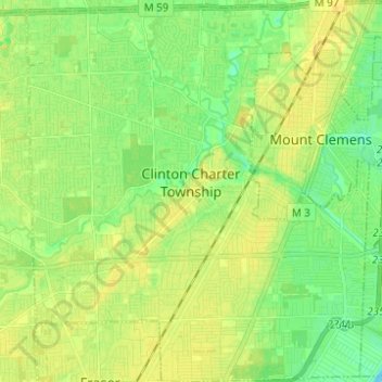
Name: Clinton Charter Township topographic map, elevation, terrain.
Average elevation: 604 ft
Minimum elevation: 568 ft
Maximum elevation: 633 ft
Macomb County trails, hiking, mountain biking, running and outdoor activities
Other topographic maps
Click on a map to view its topography, its elevation and its terrain.
Forest Lake
United States > Michigan > Macomb County > Shelby Charter Township
Average elevation: 663 ft
Chesterfield Shores
United States > Michigan > Macomb County > Chesterfield Township
Average elevation: 584 ft
Sterling Heights
United States > Michigan > Macomb County > Sterling Heights > Sterling Heights
Average elevation: 673 ft