Geolocate

Saint-James topographic map

Interactive map

Click on the map to display elevation.

About this map

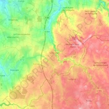
Name: Saint-James topographic map, elevation, terrain.

Location: Saint-James, Avranches, Manche, Normandy, Metropolitan France, 50240, France (48.45580 -1.44095 48.58604 -1.28673)

Average elevation: 341 ft

Minimum elevation: 49 ft

Maximum elevation: 614 ft

Other topographic maps

Click on a map to view its topography, its elevation and its terrain.

La Coquaise

France > Normandy > Manche > Flamanville

Average elevation: 108 ft

La Bihellerie

France > Normandy > Manche > Pierreville

Average elevation: 223 ft

La Rue de Bas

France > Normandy > Manche > Blainville-sur-Mer

Average elevation: 66 ft

Les Acacias

France > Normandy > Manche > Port-Bail-sur-Mer > Portbail

Average elevation: 20 ft

Le Petit Hameau

France > Normandy > Manche > Barneville-Carteret

Average elevation: 69 ft

Saint-Martin-le-Vieux

France > Normandy > Manche > Bréhal

Average elevation: 72 ft

Le Valnotte

France > Normandy > Manche > Carteret

Average elevation: 115 ft

Le Clos Versailles

France > Normandy > Manche > La Haye-du-Puits

Average elevation: 167 ft

La Planquette

France > Normandy > Manche > Gavray-sur-Sienne > Gavray

Average elevation: 249 ft

Hameau Viel

France > Normandy > Manche > Flamanville

Average elevation: 115 ft

L'Hôtel Boschet

France > Normandy > Manche > Cérences

Average elevation: 161 ft

L'Hôtel au Roy

France > Normandy > Manche > Cérences

Average elevation: 167 ft

Le Port

France > Normandy > Manche > Pontorson > Le Port

Average elevation: 43 ft

La Place

France > Normandy > Manche > Maupertus-sur-Mer > La Place

Average elevation: 236 ft

Bas Courtils

France > Normandy > Manche > Courtils > Bas Courtils

Average elevation: 20 ft

Granville

France > Normandy > Manche > Granville > Granville

Average elevation: 46 ft