Geolocate

Giresun topographic map

Interactive map

Click on the map to display elevation.

About this map

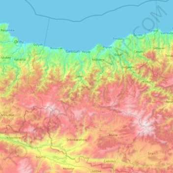
Name: Giresun topographic map, elevation, terrain.

Location: Giresun, Black Sea Region, Turkey (40.04576 37.95967 41.27900 39.18250)

Average elevation: 3,468 ft

Minimum elevation: 0 ft

Maximum elevation: 10,627 ft

Other topographic maps

Click on a map to view its topography, its elevation and its terrain.

Istanbul

Turkey > Fatih

Istanbul, located in northwestern Turkey, is a city that is uniquely situated across two continents, Europe and Asia, divided by the Bosphorus Strait. The city’s topography is characterized by a complex blend of hills, valleys, and coastal plains, which create a varied and scenic landscape. The European side…

Average elevation: 187 ft

Kopal

Turkey > Karaçoban

Average elevation: 5,699 ft

Ankara

Turkey > Ankara > Çankaya

Ankara has a cold semi-arid climate (Köppen climate classification: BSk). Under the Trewartha climate classification, Ankara has a temperate humid continental climate (Dc). Due to its elevation and inland location, Ankara has cold and snowy winters, and hot and dry summers. Rainfall occurs mostly during the…

Average elevation: 3,550 ft

Bursa

Turkey > Osmangazi

Average elevation: 1,962 ft

Antalya

Turkey > Muratpaşa

While the city itself only has modest elevation changes, Antalya has high mountains in all directions to its interior. With moisture being trapped, the local climate thus has high winter rainfall, while the interior bay setting result in very hot summers for a coastal city.

Average elevation: 384 ft

Salur

Turkey > Refahiye

Average elevation: 5,692 ft

Istanbul

Turkey > Istanbul > Fatih

Istanbul, located in northwestern Turkey, is a city that is uniquely situated across two continents, Europe and Asia, divided by the Bosphorus Strait. The city’s topography is characterized by a complex blend of hills, valleys, and coastal plains, which create a varied and scenic landscape. The European side…

Average elevation: 187 ft

Karacaören

Turkey > Menteşe

Average elevation: 2,392 ft

Istanbul

Turkey > Fatih

Istanbul, located in northwestern Turkey, is a city that is uniquely situated across two continents, Europe and Asia, divided by the Bosphorus Strait. The city’s topography is characterized by a complex blend of hills, valleys, and coastal plains, which create a varied and scenic landscape. The European side…

Average elevation: 187 ft

Erikli

Turkey > Kızıltepe

Average elevation: 1,670 ft

Aksu

Turkey > Hendek

Average elevation: 2,300 ft

Kaleyüzü

Turkey > Feke

Average elevation: 3,996 ft

İl

Turkey > Başkale > Keçilioba

Average elevation: 7,671 ft

Yeniyapan Şeyhli

Turkey > Ankara > Balâ

Average elevation: 3,235 ft

Yeniyapan Şeyhli

Turkey > Ankara > Balâ

Average elevation: 3,235 ft

Kümbet

Turkey > Yıldızeli

Average elevation: 5,331 ft

Çakmak

Turkey > Menteşe

Average elevation: 2,858 ft

Sazlı

Turkey > Ayvacık

Average elevation: 846 ft

Zekeriyaköy

Turkey > Yapraklı

Average elevation: 4,042 ft

İzmir

Turkey > Konak

Average elevation: 863 ft

Kızılelma

Turkey > Bartın

Average elevation: 164 ft

Kapaklı

Turkey > Daday

Average elevation: 3,593 ft

Dumanlı

Turkey > Gümüşhane

Average elevation: 5,761 ft

Karlı

Turkey > Eflani

Average elevation: 3,350 ft

Dikilitaş

Turkey > Kozan

Average elevation: 325 ft

Gaziantep

Turkey > Şahinbey

The plan introduced several important changes to the city's transportation network. One of the most important was the addition of a rail line to connect Gaziantep to the national rail system. Up to now, Turkish railway construction had ignored Gaziantep (partly because of its mountainous surroundings); a…

Average elevation: 2,887 ft

Arslanköy

Turkey > Toroslar

Arslanköy is a mountain town situated in the Toros Mountains at an altitude of approximately 1,475 metres (4,839 ft). The distance by road to Mersin is 51 kilometres (32 mi).

Average elevation: 5,033 ft

Tahir

Turkey > Eleşkirt

Average elevation: 7,513 ft

Hanyatak

Turkey > Akyazı

Average elevation: 2,861 ft

Kayseri

Turkey > Melikgazi

Kayseri sits at the foot of Mount Erciyes (Turkish: Erciyes Dağı), a dormant volcano that reaches an altitude of 3,917 metres (12,851 feet), more than 1,500 metres above the city's mean altitude. It contains a number of historic monuments, particularly from the Seljuk period. Tourists often pass through…

Average elevation: 4,413 ft

Gökçeovacık

Turkey > Fethiye

Average elevation: 1,883 ft

Karaca

Turkey > Çorum

Average elevation: 2,484 ft

Döngelli

Turkey > Akçakoca

Average elevation: 190 ft

Zincirlikuyu

Turkey

Average elevation: 3,159 ft

Paşadüzü

Turkey > Ovacık

Average elevation: 4,364 ft

Gökbez

Turkey > Pozantı

Average elevation: 3,025 ft

Düzoba Yaylası

Turkey > Kumru > Çatılı Mahallesi

Average elevation: 5,089 ft

Yolboyu

Turkey > Pazarcık

Average elevation: 2,395 ft

Muğla

Turkey > Menteşe

Muğla (Turkish: [ˈmuːɫa]) is a city in southwestern Turkey. The city is the center of the district of Menteşe and Muğla Province, which stretches along Turkey's Aegean coast. Muğla's center is situated inland at an altitude of 660 m and lies at a distance of about 30 km (19 mi) from the nearest seacoast…

Average elevation: 2,759 ft

Çenger

Turkey > Fethiye

Average elevation: 2,201 ft

Tatar

Turkey > Suşehri

Average elevation: 5,266 ft

Ortayol

Turkey > Başkale

Average elevation: 7,336 ft

Heybeli

Turkey > Erzincan

Average elevation: 5,013 ft

Mursallı

Turkey > Şarköy

Average elevation: 1,135 ft

Tepe

Turkey > Lice

Average elevation: 2,684 ft

Konya

Turkey > Selçuklu

Average elevation: 3,806 ft

Kozlu

Turkey > Bolu

Average elevation: 4,209 ft

Şenocak

Turkey > Haliliye

Average elevation: 1,532 ft

Beşyol

Turkey > Besni

Average elevation: 1,778 ft

Bıyıklıalanı

Turkey > Keles

Average elevation: 3,376 ft

Madas

Turkey > Tokat

Average elevation: 3,973 ft

Taurus Mountains

Turkey

The mountains have a Mediterranean climate, with dry summers and rainy winters. Temperatures vary with elevation, with warm winters on the lower coastal slopes and cold winters in the high mountains and in the interior.

Average elevation: 2,717 ft

Develik

Turkey > Ahlat

Average elevation: 6,975 ft

Akçakese

Turkey > Boyabat

Average elevation: 3,537 ft

Aşağı Tavla

Turkey > Doğubayazıt

Average elevation: 4,980 ft

Tatköy

Turkey > Selçuklu

Average elevation: 5,003 ft

Uludoruk Dağı

Turkey > Yüksekova

Average elevation: 11,033 ft

İbrahimli

Turkey > Kastamonu

Average elevation: 4,081 ft

İslamköy

Turkey > Kulp

Average elevation: 4,206 ft

Akdam

Turkey > Alanya

Average elevation: 430 ft

Tat

Turkey > Korkuteli

Average elevation: 3,274 ft

Göbekli Tepe

Turkey > Haliliye > Örencik Mahallesi

Average elevation: 2,303 ft

Kızılsu

Turkey > Şırnak

Average elevation: 2,979 ft

Arak

Turkey > Mengen

Average elevation: 2,858 ft

İslamköy

Turkey > Kulp

Average elevation: 4,206 ft

Akköy

Turkey > Bismil

Average elevation: 2,054 ft

Durupınar

Turkey > Elazığ

Average elevation: 3,898 ft

Bucakdere

Turkey > Sütçüler

Average elevation: 4,281 ft

Çanakçılar

Turkey > Bolu

Average elevation: 2,835 ft

Kocaoğlanlı

Turkey > Alanya

Average elevation: 892 ft

Çandır

Turkey > Köyceğiz

Average elevation: 443 ft

Kazıklı

Turkey > Şahinbey

Average elevation: 2,116 ft

Batıköy

Turkey > Didim

Average elevation: 23 ft

Yenikent

Turkey > Aksaray

Average elevation: 3,022 ft

Ümit

Turkey > Kastamonu

Average elevation: 3,442 ft

Trabzon

Turkey > Trabzon > Ortahisar

Average elevation: 791 ft

Kartalkaya Kayak Merkezi

Turkey > Seben > Gerenözü Köyü

Average elevation: 6,572 ft

Çandır

Turkey > Milas

Average elevation: 577 ft

Çıralı

Turkey > Yusufeli

Average elevation: 4,364 ft

Bostanlı

Turkey > Kâhta

Average elevation: 1,877 ft

Akçakent

Turkey > Nizip

Average elevation: 1,811 ft

Altaş

Turkey > Ardahan

Average elevation: 5,938 ft

Çandır

Turkey > Çivril

Average elevation: 2,700 ft

Vagon Park

Turkey > Sakarya > Adapazarı

Average elevation: 171 ft

Istanbul

Turkey > Istanbul > Fatih

Average elevation: 187 ft

Istanbul

Turkey > Fatih

Istanbul, located in northwestern Turkey, is a city that is uniquely situated across two continents, Europe and Asia, divided by the Bosphorus Strait. The city’s topography is characterized by a complex blend of hills, valleys, and coastal plains, which create a varied and scenic landscape. The European side…

Average elevation: 187 ft

Kiriş

Turkey > Kemer

Average elevation: 144 ft

Çokal Dam

Turkey > Gelibolu > Çokal

Average elevation: 318 ft

Murat Dağı

Turkey > Gediz

Average elevation: 6,906 ft

Uludağ

Turkey > Osmangazi

Uludağ (Turkish pronunciation: [ˈuɫudaː]), the ancient Mysian or Bithynian Olympus (Greek: Όλυμπος), is a mountain in Bursa Province, Turkey, with an elevation of 2,543 m (8,343 ft).

Average elevation: 7,431 ft

Garipce

Turkey > Korkuteli

Average elevation: 2,808 ft

Şahintepe

Turkey > Bismil

Average elevation: 1,772 ft

Uludağ

Turkey > Osmangazi

Uludağ (Turkish pronunciation: [ˈuɫudaː]), the ancient Mysian or Bithynian Olympus (Greek: Όλυμπος), is a mountain in Bursa Province, Turkey, with an elevation of 2,543 m (8,343 ft).

Average elevation: 7,431 ft

Sarıcaeli

Turkey > Çanakkale Merkez

Average elevation: 390 ft

Erzurum

Turkey > Yakutiye

Average elevation: 6,854 ft

Kösedağ

Turkey > Suşehri

Average elevation: 6,850 ft

Sömek

Turkey > Silifke

Average elevation: 2,877 ft

Söbeçimen

Turkey > Çayıralan

Average elevation: 5,669 ft

Göynük

Turkey > Göksun

Average elevation: 5,676 ft

Çokal

Turkey > Gelibolu

Average elevation: 344 ft