
San Onofre topographic map
Interactive map
Click on the map to display elevation.
About this map
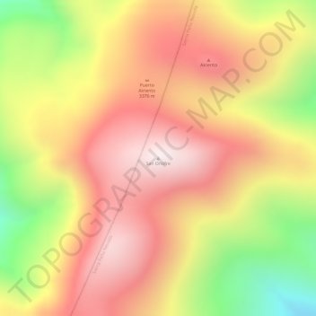
Name: San Onofre topographic map, elevation, terrain.
Location: San Onofre, General Zaragoza, Nuevo León, Mexico (23.80048 -99.84680 23.80058 -99.84670)
Average elevation: 10,781 ft
Minimum elevation: 9,318 ft
Maximum elevation: 11,696 ft
Other topographic maps
Click on a map to view its topography, its elevation and its terrain.
Monterrey
The city of Monterrey is 540 metres (1,770 ft) above sea level in the northeastern state of Nuevo León. Monterrey translated from Spanish to English is "King Mount" or "King mountain", which refers to the city's topography and the large mountains that surround it. The Santa Catarina River—dry most of the…
Average elevation: 2,825 ft
National Park Summits of Monterrey
Mexico > Nuevo León > Santiago
The park is located in the northern portion of the Sierra Madre Oriental, which was formed by rock folding of marine based sedimentary strata during the Eocene epoch in the Laramide orogeny period. The marine sedimentary rock rose over the years to an elevation of 2,260 m (7,410 ft) above sea level. The…
Average elevation: 4,938 ft
Bustamante
Bustamante is located in an irrigated valley at the mouth of a well-watered canyon in the headwaters of the Sabinas River, a tributary of the Salado River. The Sierra de Gomas to the west of the town rise to an elevation of 5,591 feet (1,704 m) at the Cabeza de Leon four miles south-southwest of Bustamante.…
Average elevation: 2,047 ft
San Pedro Garza García
On the slopes of Cerro de Chipinque, within the Cumbres de Monterrey national park, is the Chipinque Ecological Park, with 1,791 hectares, covering altitudes from 730 to 2,200 meters with representative flora and fauna. The annual average temperature is 21 °C.
Average elevation: 2,835 ft