
Lo Manthang topographic map
Interactive map
Click on the map to display elevation.
About this map
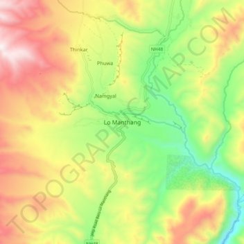
Name: Lo Manthang topographic map, elevation, terrain.
Average elevation: 12,986 ft
Minimum elevation: 11,542 ft
Maximum elevation: 14,636 ft
Recently a series of at least twelve caves were discovered north of Annapurna and near the village, decorated with ancient Buddhist paintings and set in sheer cliffs at 14,000 feet (4,300 m) elevation. The paintings show Newari influence, dating to approximately the 13th century, and also contain Tibetan scripts executed in ink, silver and gold and pre-Christian era pottery shards. Explorers found stupas, decorative art and paintings depicting various forms of the Buddha, often with disciples, supplicants and attendants, with some mural paintings showing sub-tropical themes containing palm trees, billowing Indian textiles and birds.