
Gosport topographic map
Interactive map
Click on the map to display elevation.
About this map
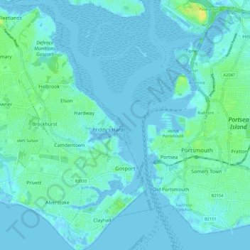
Name: Gosport topographic map, elevation, terrain.
Location: Gosport, Hampshire, England, United Kingdom (50.77329 -1.21430 50.84026 -1.11177)
Average elevation: 10 ft
Minimum elevation: -13 ft
Maximum elevation: 59 ft
Other topographic maps
Click on a map to view its topography, its elevation and its terrain.
Cocksford Firs East
United Kingdom > England > Hampshire > Basingstoke and Deane > Steventon
Average elevation: 502 ft
Farnborough
United Kingdom > England > Hampshire > Rushmoor
Farnborough is located in the northeastern corner of the county of Hampshire, near the border with Surrey. The town occupies a valley setting, with the main urban area situated between the River Blackwater to the east and higher ground to the west. The topography gradually rises from the valley floor, reaching…
Average elevation: 269 ft
Sherborne St John
United Kingdom > England > Hampshire > Basingstoke and Deane
Average elevation: 302 ft