
Central Kalimantan topographic map
Interactive map
Click on the map to display elevation.
About this map
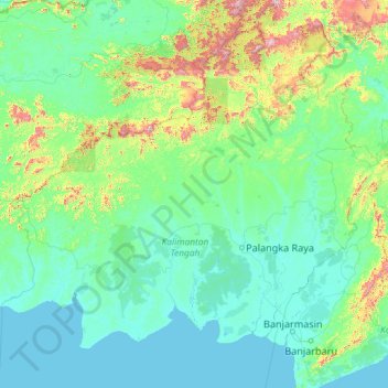
Name: Central Kalimantan topographic map, elevation, terrain.
Location: Central Kalimantan, Indonesia (-4.05958 110.73033 1.06042 115.85033)
Average elevation: 472 ft
Minimum elevation: -3 ft
Maximum elevation: 6,385 ft
Other topographic maps
Click on a map to view its topography, its elevation and its terrain.
Palangka Raya
Indonesia > Central Kalimantan
Palangka Raya borders Gunung Mas Regency to the north, Katingan Regency to the west, and Pulang Pisau Regency to the south and east. The area's soil consists mostly of peat and alluvium in its southern part and podzol on the northern part of the city. Overall, podzol soil dominates the city soil with 218,486…
Average elevation: 75 ft
Murung Raya
Indonesia > Central Kalimantan
The regency has an area of 23,700 km2 and lies between 114°27'00 to 115°49'00 East longitude and 0°58'30 North latitude to 1°26'00 South latitude. It occupies the valleys and foothills of the southern and eastern slopes of the Müller Mountains, and rises to 1730 m at Mount Lesung on its northern border.…
Average elevation: 1,198 ft
Palangka Raya
Indonesia > Central Kalimantan
Palangka Raya borders Gunung Mas Regency to the north, Katingan Regency to the west, and Pulang Pisau Regency to the south and east. The area's soil consists mostly of peat and alluvium in its southern part and podzol on the northern part of the city. Overall, podzol soil dominates the city soil with 218,486…
Average elevation: 75 ft
South Barito
Indonesia > Central Kalimantan
Regency's topography is flat and low-lying but on the most part except on northern parts where mountain ranges could be found. The regency's low-lying regions are wetlands and swamps with little variations.
Average elevation: 125 ft
Tanjung Puting National Park
Indonesia > Central Kalimantan > West Kotawaringin
Average elevation: 26 ft
Bukit Baka Bukit Raya National Park
Indonesia > Central Kalimantan > Katingan
Average elevation: 1,007 ft