
Pago Pago topographic map
Interactive map
Click on the map to display elevation.
Pago Pago
Ceramic findings have been retrieved at Vaipito, an inland area within Pago Pago village. A deposit here is thought to be an old hill-slope below a living area where people threw away their waste. Numerous large ceramic pieces have been retrieved here. The layer with the ceramics dates back to the time between 350 BCE and 10 CE. Another site, Fo’isia, is located approximately 100 meters from Vaipito, at the same elevation inland in Pago Pago. During sewer line construction, the American Samoa Power Authority noticed many broken pieces of clay pottery. Five dates associated with the ceramics indicate a time range between 370 BCE and 130 CE.
About this map
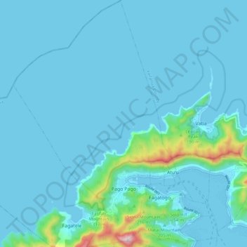
Name: Pago Pago topographic map, elevation, terrain.
Average elevation: 164 ft
Minimum elevation: -7 ft
Maximum elevation: 1,952 ft
Eastern District trails, hiking, mountain biking, running and outdoor activities
Other topographic maps
Click on a map to view its topography, its elevation and its terrain.