
West Java topographic map
Interactive map
Click on the map to display elevation.
About this map
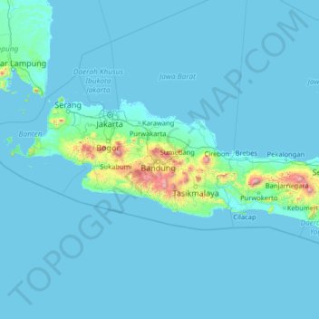
Name: West Java topographic map, elevation, terrain.
Location: West Java, Indonesia (-9.44919 105.08047 -4.32919 110.20047)
Average elevation: 243 ft
Minimum elevation: -7 ft
Maximum elevation: 10,381 ft
Other topographic maps
Click on a map to view its topography, its elevation and its terrain.
Cimahi
Cimahi, located 180 km south east of Jakarta, is situated between Bandung and West Bandung Regency. Cimahi comprises three districts (kecamatan), which in turn are sub-divided into fifteen urban villages (kelurahan). Its lowest elevation is 685 metres (2,247 ft) above sea level and directs to Citarum River.…
Average elevation: 2,556 ft
Kuningan
Kuningan is located in the eastern part of West Java. It is bordered by Cirebon Regency to the north, Majalengka Regency to the west, Ciamis Regency and Cilacap Regency to the south, and by Brebes Regency and Cilacap Regency (both in Central Java Province) to the east and southeast. The regency capital is the…
Average elevation: 1,430 ft
Patenggang Lake
Indonesia > West Java > Kabupaten Bandung > Rancabali > Bauan
Patenggang Lake (Indonesian: Situ Patenggang) is a lake located in the area of natural tourist attractions in the southern Bandung City, West Java, Indonesia, to be exact it is in Ciwidey village. Located at an altitude of 1600 meters above sea level, this lake has a very exotic landscape. The lake is spread…
Average elevation: 5,627 ft
Ciliwung
Mean rainfall reaches 3,125 mm, with a mean annual discharge of 16 m3/s as measured at Ciliwung Ratujaya observation station (231 km2). With such topographical, geological, and hydrological features, the Ciliwung River is often overflowing and inundating parts of Jakarta. The population along the Ciliwung…
Average elevation: 751 ft
Bogor
The city is situated in the western part of Java island, about 53 km south of the metropolis of Jakarta and 85 km northwest of the city of Bandung, the administrative center of West Java Province. Bogor spreads over a basin near the volcanoes of Salak (which peaks at about 12 km south) and Mount Gede (whose…
Average elevation: 1,017 ft
Sukabumi
At an altitude of approximately 584 m (1,916 ft), the city is a minor hill station resort, with a cooler climate than the surrounding lowlands. The area around Sukabumi is also a popular destination for whitewater rafting. Tea and Rubber production is a major industry in the area. The suburban area surrounding…
Average elevation: 1,870 ft
Tasikmalaya
The city is located in the mountainous Priangan region of Java at an elevation of 351 metres (1,151 feet).
Average elevation: 1,204 ft
Megamendung
Much of the district lies in an elevation of 500-600 metres, which moderates the temperature, and causing contrast to the heat of Greater Jakarta and other adjacent low-lying lands. Though much of the built-up area is not necessarily on rugged terrain, uneven ground is the most common terrain as it stands…
Average elevation: 2,434 ft
Sukabumi
At an altitude of approximately 584 m (1,916 ft), the city is a minor hill station resort, with a cooler climate than the surrounding lowlands. The area around Sukabumi is also a popular destination for whitewater rafting. Tea and Rubber production is a major industry in the area. The suburban area surrounding…
Average elevation: 1,870 ft
PT.Sinkona Lestari Indoesia Backyard Park
Indonesia > West Java > Subang > Subang
Average elevation: 2,441 ft
Gunung Ciremai National Park
Indonesia > West Java > Kuningan > Padabeunghar
Average elevation: 2,881 ft