
Klarenbeek topographic map
Interactive map
Click on the map to display elevation.
About this map
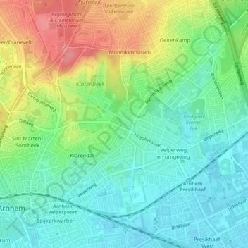
Name: Klarenbeek topographic map, elevation, terrain.
Location: Klarenbeek, Arnhem, Gelderland, Nederland, 6824KK, Nederland (51.99341 5.93079 51.99342 5.93083)
Average elevation: 128 ft
Minimum elevation: 33 ft
Maximum elevation: 295 ft
Other topographic maps
Click on a map to view its topography, its elevation and its terrain.
Arnhem
Nederland > Gelderland > Arnhem
De stad telt meerdere theaters, waarvan het Stadstheater Arnhem het belangrijkste is. Dit theater doet dienst als schouwburg en als concertzaal. Musis Sacrum op het Velperplein is het vaste concertgebouw van Phion, het orkest van Gelderland en Overijssel. Theater aan de Rijn, KAB Posttheater, Huis van Puck,…
Average elevation: 79 ft