
Candelaria topographic map
Interactive map
Click on the map to display elevation.
About this map
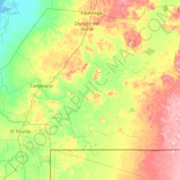
Name: Candelaria topographic map, elevation, terrain.
Location: Candelaria, Campeche, Mexico (17.81242 -91.32840 18.50769 -90.23554)
Average elevation: 226 ft
Minimum elevation: -7 ft
Maximum elevation: 725 ft
Other topographic maps
Click on a map to view its topography, its elevation and its terrain.
Hecelchakán
Mexico > Campeche > Hecelchakán
It is at an altitude of 10 m above sea level.
Average elevation: 112 ft
Campeche
Mexico > Campeche > Municipio de Campeche
Before the current shield was adopted, there was a process to constitute a shield as an officer. The first project was presented in 1772 before the possible elevation to the title of city of the town of San Francisco de Campeche, when requested by the Cabildo de Campeche in a contest for the election of shield…
Average elevation: 59 ft