
Montivilliers topographic map
Interactive map
Click on the map to display elevation.
About this map
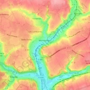
Name: Montivilliers topographic map, elevation, terrain.
Average elevation: 210 ft
Minimum elevation: 0 ft
Maximum elevation: 351 ft
Other topographic maps
Click on a map to view its topography, its elevation and its terrain.
Phare d'Antifer
France > Normandy > Seine-Maritime > La Poterie-Cap-d'Antifer > Jumel
Average elevation: 151 ft